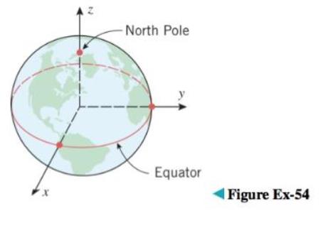
The Earth’s rotation causes a flattening at the poles, so its shape is often modeled as an oblate spheroid rather than a sphere (see Exercise 53 for terminology). One of the models used by global positioning satellites is the World Geodetic System of 1984 (WGS-84), which treats the Earth as an oblate spheroid whose equatorial radius is 6378.1370 km and whose polar radius (the distance from the Earth’s center to the poles) is 6356.5231 km. Use the WGS-84 model to find an equation for the surface of the Earth relative to the coordinate system shown in the ac-companying figure.
The Earth’s rotation causes a flattening at the poles, so its shape is often modeled as an oblate spheroid rather than a sphere (see Exercise 53 for terminology). One of the models used by global positioning satellites is the World Geodetic System of 1984 (WGS-84), which treats the Earth as an oblate spheroid whose equatorial radius is 6378.1370 km and whose polar radius (the distance from the Earth’s center to the poles) is 6356.5231 km. Use the WGS-84 model to find an equation for the surface of the Earth relative to the coordinate system shown in the ac-companying figure.
The Earth’s rotation causes a flattening at the poles, so its shape is often modeled as an oblate spheroid rather than a sphere (see Exercise 53 for terminology). One of the models used by global positioning satellites is the World Geodetic System of 1984 (WGS-84), which treats the Earth as an oblate spheroid whose equatorial radius is 6378.1370 km and whose polar radius (the distance from the Earth’s center to the poles) is 6356.5231 km. Use the WGS-84 model to find an equation for the surface of the Earth relative to the coordinate system shown in the ac-companying figure.
System that uses coordinates to uniquely determine the position of points. The most common coordinate system is the Cartesian system, where points are given by distance along a horizontal x-axis and vertical y-axis from the origin. A polar coordinate system locates a point by its direction relative to a reference direction and its distance from a given point. In three dimensions, it leads to cylindrical and spherical coordinates.
Sketch a hyperbolic basketball in a cartesian coordinate plane.
The first artificial satellite to orbit the earth was Sputnik I. Its highest point above earth's
surface was 947 km, and its lowest point was 228 km. The center of the earth was at one
focus of the elliptical orbit. The radius of the earth is 6378 km. Find the eccentricity ofthe
orbit.
Nabil is writing a science fiction novel that takes place in anothergalaxy. In her galaxy, all the planets travel in an elliptical orbitaround their star. The majority of the plot of Nabil’s story takesplace on the planet Tanus which orbits a star named Ini. Thelength of Tanus’ major axis is 150 million miles and the length ofits minor axis is 75 million miles. The star Ini is located at afocus of the elliptical orbit.
Write an equation that models the movement of Tanus around its star. Explain how youdetermined your equation and show your work
. Create a graph of Tanus’ movement around Ini using your equation from question 1. Labelyour graph with the position of the star and the planet.
Suppose that Nabil would like to create a model that shows the path of Tanus’ orbit aroundIni. For ease of programming, Nabil would like Ini to be located at the coordinates (0, 0). Writean equation that models the movement of Tanus around Ini, where Ini is located at (0, 0). Explainthe changes to your…
Precalculus: Mathematics for Calculus (Standalone Book)
Knowledge Booster
Learn more about
Need a deep-dive on the concept behind this application? Look no further. Learn more about this topic, calculus and related others by exploring similar questions and additional content below.


 Algebra & Trigonometry with Analytic GeometryAlgebraISBN:9781133382119Author:SwokowskiPublisher:Cengage
 Holt Mcdougal Larson Pre-algebra: Student Edition...AlgebraISBN:9780547587776Author:HOLT MCDOUGALPublisher:HOLT MCDOUGAL
 Elementary Linear Algebra (MindTap Course List)AlgebraISBN:9781305658004Author:Ron LarsonPublisher:Cengage Learning
 Mathematics For Machine TechnologyAdvanced MathISBN:9781337798310Author:Peterson, John.Publisher:Cengage Learning,
 Elementary Geometry For College Students, 7eGeometryISBN:9781337614085Author:Alexander, Daniel C.; Koeberlein, Geralyn M.Publisher:Cengage,